Urban encroachment – untangling drivers and dynamics of land-use transitions in ecologically sensitive areas
Manja Hoppe Andreasen, Associate Professor at the Department of Geosciences and Natural Resource Management at KU discusses her research project on the dynamics of urban encroachment in urban spaces of Ghana and Tanzania, funded by Independent Research Fund Denmark.

By Manja Hoppe Andreasen, Associate Professor at the Department of Geosciences and Natural Resource Management at KU.
| If you are interested in Manja Andreasen's work, please visit her researcher profile page and find her on LinkedIn. |
Urban encroachment – untangling drivers and dynamics of land-use transitions in ecologically sensitive areas
Africa’s cities are growing rapidly – both demographically and spatially. Urban expansion wields significant pressure on surrounding landscapes and ecosystems. In Africa, app. 60% of land converted to urban uses in the 1970-2010 period consisted of natural areas (Güneralp et al. 2020). This has implications for the sustainability, resilience and livability of cities. Natural areas provide a range of benefits for cities, such as surface water management, ground water recharge, air purification, temperature regulation and recreational spaces (e.g. Cilliers et al. 2013, Schäffler and Swilling 2013, Wangai et al. 2016, du Toit et al. 2018). The combined effects of rapid urban expansion, encroachment upon ecologically sensitive areas and more extreme weather events due to climate change will exacerbate existing challenges with urban water management in African cities.
I lead a newly started research project titled ”Urban encroachment - untangling drivers and dynamics of land-use transitions in ecologically sensitive areas” (2024-2028). Through a combination of policy analysis, in-depth case studies and analysis of satellite imagery, the research aims to gain new insights into urban expansion pressures within ecologically sensitive areas in African cities. The research entails a comparative study of two rapidly growing African cities – Accra in Ghana and Dar es Salaam in Tanzania. As is characteristic for many African cities, expansion is fuelled primarily by unregulated residential sprawl. My recent research in Accra revealed the intertwinement of unregulated urban expansion, widespread encroachment on ecologically sensitive areas and exacerbating flood risk (Andreasen et al. 2022, Andreasen et al. 2023). While there are many similarities between Dar es Salaam and Accra in city size, growth dynamics, geophysical characteristics and water challenges, urban expansion is shaped by different urban governance systems. Typical for the West African context, urban land administration in Ghana is characterized by legal pluralism, co-existing customary and statutory tenure systems and strong influence of traditional authorities. In the Tanzanian context, all land is in principle vested in the state, though urban areas often have vibrant informal land markets and private landowners enjoy a relatively high degree of de-facto tenure.
During my initial fieldwork in Accra and Dar es Salaam in the autumn of 2024, I have begun untangling how ecologically sensitive areas are identified, designated and managed within the urban governance systems. I have reviewed existing legislation, policies and spatial plans and interviewed a range of urban planners and policymakers involved in urban planning, land administration and environmental governance in both cities. It is evident that governance arrangements concerning ecologically sensitive areas are highly complex, very contextual and politically sensitive. Five themes emerge from the initial fieldwork that needs further investigation and sets the direction for the research in the coming years.
The enforcement gaps: One of the major challenges is the gaps between existing policies, regulations and plans, as they are on paper, and how they are administered and implemented in practice. Both cities have a number of ecologically sensitive areas, which are formally designated by municipal, regional or national authorities as areas that should be restricted from urban development due to their significance for wildlife habitat, biodiversity, surface water management and flood risk mitiation Many informants highlight existing policies and legislation positively, due to the strong measures for protection of designated ecologically sensitive areas. However, all informants also assert that enforcement of existing policies and plans is fraught with difficulties.
Shallow municipal capacities: Municipal authorities are at the forefront of enforcement. They are supposed to ensure that no one build houses without valid building permits, that building permits are not issued for land within ecologically sensitive areas and that developments on the ground are in compliance with the permits issued. Ultimately, municipal authorities have the mandate to issue ”stop work” orders and enforce demolitions for developments encroaching on ecologically sensitive areas. However, municipal planning departments are under-staffed, under-ressourced and overwhelmed by large territories and populations to monitor. In Dar es Salaam, there seems be a monitoring advantage, due to a highly decentralized system of local governance, where politically elected leaders at sub-ward level play a role in monitoring and reporting non-compliance to municipal authorities.
Ambivalent boundary delinations: Efficient enforcement relies on clear and unambivalent spatial delinations of the designated ecologically sensitive areas that are supposed to be protected and preserved. Tanzania and Ghana have legislations to protect vegetated buffer zones along rivers, streams and other water bodies. Buffer zone legislations are difficult to enforce in practice, though. Different buffer zone lengths apply to different categories of water bodies and it is not always clear what buffer zone applies to a specific water body. Ambivalence can arise due to unclarity on from where the buffer zone should be measured in practice. In Tanzania, the legislation stipulates that the buffer zone is measured from the “highest water mark”, but municipal planners complain that it is not clear where the highest water mark is for specific water bodies within their jurisdictions.
Political interference: Efficient enforcement is obfuscated by political interference. Municipal planners or environmental officers may receive calls from politicians asking them to overlook encroachments or abandon enforcement measures. Locally elected politicians may serve the interests of their constituencies. “Encroachers are also voters”, as one planner remarked. Requests may also come from influential national level politicians. Sometimes, “requests” are accompanied by covert threats of zealous planners being transferred to a remote rural district or subject to accusations of corruption. Enforcement is particularly high-risk for municipal planners in Accra. Ghanaian land markets are characterised by a high level of contestation and ”landguardism”, which involves the use of violence and threats to protect and guard property rights (Ehwi and Mawuli 2021). Therefore, municipal planners may need security detail from the police or military in order to issue ”stop work” orders or enforce demolitions.
Corrupt practices: Concerns regarding corrupt practices among key actors came up again and again in interviews. Interfering politicians are accused of being in the pocket of large investors and business owners. Municipal planners are accused of accepting bribes for issuing building permits where they should not have been issued. National authorities in the lands sector are accused of issuing title deeds and approving re-zoning schemes within ecologically sensitive areas. The empirical validity of such accusations is of course difficult to ascertain, but it does provide a indication of an governance system fraught with distrust and suspicion, where everyone thinks the worst of each other, and where this may, to some degree, serve to legimize malpractice.
High-end real estate development in Sakumono Lagoon
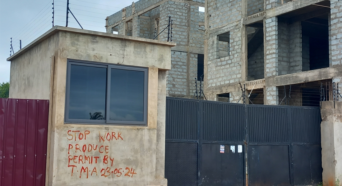
The coastal wetland of Sakumono Lagoon east of central Accra is designated as a Ramsar site, i.e. a wetland of international importance for biodiversity. As a Ramsar site, Sakumono is, at least in theory, under the jurisdiction of the Forestry Commission, though it has not taken much action against the increasing pressure from encroachment. In recent decades, Sakumono has become a fashionable residential area that attracts many affluent housebuilders and large real estate developers. Emerging residential developments in the area are highly disputed. Part of the lagoon falls within the jurisdiction of Tema Metropolitan Assembly that has recently issued stop work orders to a number of large inverstors. The Greater Accra Regional Coordinating Council has also stepped into the dispute to back up the municipality.
Piecemeal encroachments in Kibugumo mangrove forest

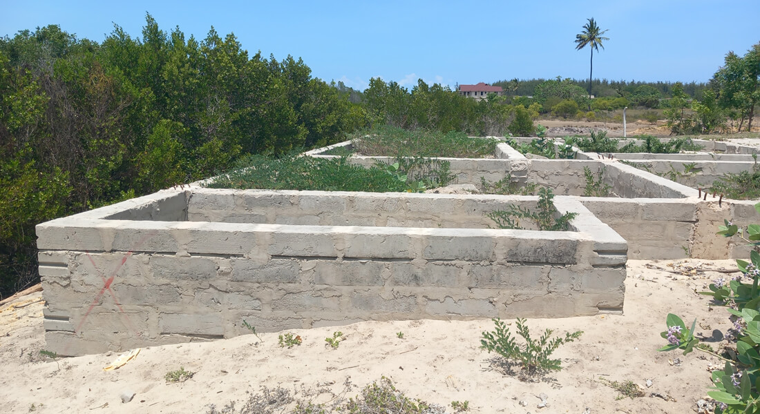
Kibugumo mangrove forest is a large coastal wetland and mangrove forest on the Kigamboni peninsula. Under Tanzanian law, mangrove forests are strictly protected from human interference and falls under the jurisdiction of Tanzania Forest Services. Construction is also prohibited within a 60 metre buffer zone from the mangrove forests. Emerging residential developments close to the mangrove are subject to dispute between landowners and authorities. Tanzania Forest Services and Kigamboni Municipal Council assert that some of the developments fall within the buffer zone, while local landowners argue that in fact it is the mangrove which has expanded towards their properties in recent years.
This research is supported by a Sapere Aude Starting Grant from Independent Research Fund Denmark.
References
Andreasen, M. H., J. Agergaard, A. N. M. Allotey, L. Møller-Jensen and M. Oteng-Ababio (2023). Built‑in Flood Risk: the Intertwinement of Flood Risk and Unregulated Urban Expansion in African Cities. Urban Forum 34: 385-411. https://doi.org/10.1007/s12132-022-09478-4
Andreasen, M. H., J. Agergaard, R. Y. Kofie, L. Møller-Jensen and L. Oteng-Ababio (2022). Urban encroachment in ecologically sensitive areas: drivers, impediments and consequences. Buildings and Cities 3(1): 920-938. https://doi.org/10.5334/bc.210
Cilliers, S., J. Cilliers, R. Lubbe and S. Siebert (2013). Ecosystem services of urban green spaces in African countries—Perspectives and challenges. Urban Ecosystems 16: 681–702. https://doi.org/10.1007/s11252-012-0254-3
du Toit, M. J., S. S. Cilliers, M. Dallimer, M. Goddard, S. Guenat and S. F. Cornelius (2018). Urban green infrastructure and ecosystem services in sub-Saharan Africa. Landscape and Urban Planning 180: 249-261. https://doi.org/10.1016/j.landurbplan.2018.06.001
Ehwi, R. J., and D. A. Mawuli (2021). ‘Landguardism’ in Ghana: Examining public perceptions about the driving factors. Land Use Policy 109: 105630. https://doi.org/10.1016/j.landusepol.2021.105630
Güneralp, B., M. Reba, B. U. Hales, E. A. Wentz and K. Seto (2020). Trends in urban land expansion, density, and land transitions from 1970 to 2010: A global synthesis. Environmental Research Letters 15: 044015. https://doi.org/10.1088/1748-9326/ab6669
Schäffler, A. and M. Swilling (2013). Valuing green infrastructure in an urban environment under pressure—The Johannesburg case. Ecological economics 86: 246–257. https://doi.org/10.1016/j.ecolecon.2012.05.008
Wangai, P. W., B. Burkhard and F. Müller (2016). A review of studies on ecosystem services in Africa. International Journal of Sustainable Built Environment 5: 225–245. https://doi.org/10.1016/j. ijsbe.2016.08.005
